


And it's in the National Scenic Area
- Aug 3, 2016
- 2 min read
On all subsequent trips up to our property in the Gorge we tested out building locations (the view! the wind!), conjured up architecture, counted trees, pipe-dreamed.
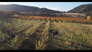
The farm is above the tiny town of Mosier just back from the bluff in an area known as “Rocky Prairie.” Our land isn’t rocky since it is nestled in a unique little valley of topsoil below the foothills. But the rest of our area is windswept high prairie meadowland, dotted with wild dog roses, out-of-control blackberries, old oaks, bigleaf maples, Ponderosas, and giant volcanic boulders.


Our view is across the Columbia River Gorge to the Washington side, where we can keep an eye on the color changes on the Coyote Wall of the syncline. Clouds are entire travel tales, and January is rainbow season. It’s dramatic, as is most every view in the Gorge, formed by the combined forces of ancient volcanoes and endless water over thousands of years. Check out Beautiful Hood River for some amazing photos.
This is the Columbia River Gorge National Scenic Area, a protected area along the river on both the Washington and Oregon sides from just outside of Portland and continuing straight east out past The Dalles. The NSA was signed into law by President Reagan in 1986 and has a fat rulebook of what can be built there and what cannot. It was not intended to discourage growth in the area, just to prevent it from being rampant and rapacious and destructive. No one wants to wreck the views.

Of course we got all this information in the form of handouts and building guides and links and color charts when we bought the property. Several people warned, “You realize you’ll be building in the National Scenic Area, right?” We were too excited to read or study or investigate the implications. Ignorance was bliss!


Working on projects that target US audiences has made me realize that user expectations are often higher in terms of experience and content quality. It’s not enough to just be present online; everything needs to feel aligned and intentional. While reviewing Rhillane Marketing Agency US, I noticed an approach that emphasizes this kind of coherence, which is something I find particularly relevant. It helped me better understand how to approach projects with a more holistic mindset.